Wine connoisseurs, cheese aficionados, and outdoor enthusiasts can unite over this breathtakingly beautiful hike high in the heart of the Alps. Completing a total circumnavigation of Western Europe’s tallest peak, Mont Blanc, this adventure will challenge you, awe you, and inspire you along one of the world’s most famous trails.

Overview: 3 countries, 7 days, 110 miles, and 33,000 vertical feet.
The Tour du Mont Blanc (TMB) is a trail that goes through France, Italy, and Switzerland, and which is walked, cycled, and run by thousands of people every year. The most popular time to hit the trail is between June and September, any time before or after that and you’ll run into worsening weather and snowy routes. There are navigational signs all along the entire trail, and in high season you should have plenty of company with other hikers, so there should be plenty of ways to help you stay on track (or trail).
People head both directions on the TMB, but Kathleen and I chose to go counterclockwise since the views are more promising and the difficult sections more short-lasting. Many people use companies that set up your TMB experience start to finish and save a whole lot of time, coordination, and sweat. Whether you use an agency or not, you’ll want to be sure to book your accommodations far ahead of time as they do fill up in the busy seasons quickly (we had to adjust our itinerary because five months out, certain hostels were already full).

I would highly recommend picking up a copy of Trekking the Tour du Mont Blanc by Kev Reynolds for a completely comprehensive history and how-to of this adventure (distances, elevations, and times in this post are pulled from here).
A few important tips & tricks before you start planning your trip:
- There are plenty of places to stop for food and water along the TMB, so no need to pack much food or water weight.
- Walking times on the trail signs are for people with a FAST pace.
- Cable cars and public busses are sometimes available, but don’t rely on them. Many have limited hours + stops.
- Carry plenty of cash, both Euros and Swiss Francs, at all times.
- Auberges (hostels) expect you to bring your own towel, and sometimes a sleeping sheet or sleeping bag.
- Dinners and breakfasts are included in your stay and are often large cafeteria/summer camp style; meaning you can typically serve yourself as much as you’d like. Beer, wine, and coffee is ALWAYS available for purchase.
- You can actually get your overnight bags delivered to your next accommodation each night, so you only have to carry a light daypack with water (for relatively cheap).
- Do not expect to have access to wifi along the TMB.
- Do not expect to have access to laundry facilities along the TMB – Get used to shower/sink washing your clothes.
- Almost everybody speaks English.
This is a super popular trail for young backpackers, honeymooners, and seniors 60 & up. There are solo hikers and groups of 12+ people, of every experience level. Whether you spend 7 days or 12 days on the trail, there should be nothing daunting about this trek as long as you pick an itinerary that you’re comfortable with.

Day 1: Les Houches to Les Contamines
Distance: 16 km
Height gain: 646m
Height loss: 633m
Time: 5-5.5 hours
Les Houches or Chamonix-Mont-Blanc are the two main starting off points for the Tour du Mont Blanc, depending on which direction you’re going. Both are large towns with Tourism Centres, laundry facilities, gear shops, and limitless restaurant and lodging options. We loaded our backpacks up with the bare essentials (see packing list below) and left our larger travel bags here, to be delivered to us at the end of the trek in Chamonix.
This first leg of the journey will include more road walking than any other part of this trek. Also unlike a few of the other stages, today you’ll be walking through a number of towns and have plenty of opportunities to fuel up or fill up your water bottles.
Today is a good warm up to kick your legs into hiking mode. There is an alternative stage on this first day that will nearly double your elevation gain, in case you’re feeling extra strong. If you start early, you should arrive in Les Contamines with plenty of time to enjoy lunch, shower, and explore the town while still in sunlight.
Day 2: Les Contamines to Refuge les Mottets
Distance: 20km
Height gain: 1579m
Height loss: 876m
Time: 7.5-8 hours
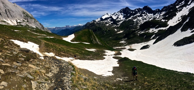
This second day of the entire trek may have been one of our most challenging, and most rewarding. Beginning at sunrise, we followed the Val Montjoie through a lush green forest, past rolling dairy plains, and up a snow-covered path to the top of Col du Bonhomme. All along the way, we’d stop to look at the valley stretching out below us and admire the views, and our progress.
The top of Col du Bonhomme was decked in snow and required some careful side-stepping into the steepest bit. It was here that we noticed other hikers’ reconsideration of their footwear, or lack of other gear like trekking poles.
From the top of the Col, we had two options – a shortcut to the west that would land us right at our accommodation for the night, or the safer traditional route that would take us down to Les Chapieux. We cut off a couple hours of flat, tiresome walking by ascending up to 2,665m to the Col des Fours.
We were here in mid-July, not considered early season at all. However, our crossing over Col des Fours was completely snow-covered and made for a painstakingly slow and careful descent down into the Ville des Glaciers (an hour upvalley from Les Chapieux). Crampons would definitely have been necessary just one month before.

One of our most important lessons was learned this day. Both of us put plenty of sunscreen on our faces, but by the time we arrived at Refuge les Mottets, we realized the rest of our bodies were horribly, unbearably burnt. We’d spend the next few nights unable to sleep, every movement of our limbs causing intense and immediate pain. Learn from our mistakes: When traveling on snow, always layer up with clothes and sunscreen.
Both of us loved Refuge les Mottets with its dormitory-style rooms and summer-camp-style cafeteria, which made it easy to meet and chat with other hikers. Before dinner we got to enjoy a pretty spectacular sunset sitting at the top of the valley accompanied by a few ice-cold local beers. And at dinner, food was served in large troughs and passed down the table – plenty for seconds, thirds, as much as you could fill your stomach.

Day 3: Refuge les Mottets to Courmayeur
Distance: 28km
Height gain: 1460m
Height loss: 1820m
Time: 8-10.5 hours
We woke up to a beautifully clear, crisp morning at Refuge les Mottets. This auberge was converted from a dairy farm and retains all of its unique and original charm. Tucked away into the green hills beneath Mont Blanc, the building caters exclusively to trekkers, while the farm still produces some of the best and widely-sold cheese in the French Alps. Most of us enjoyed this renowned cheese for dinner, breakfast, and snuck a couple extra slices for the hike ahead.

We were on the trail early this morning, coming up on the Col de la Seigne, our crossing from France into Italy. It was a cold, windy morning when we watched the clouds open up before us and we could peer into Vallon de la Lee Blanche and admire the mountains skyrocketing around us. It was a truly stunning landscape.
This third day was long, undulating, and just short of brutal. We were blessed with gorgeous views and weather at every point of the hike, but the trail seemed to stretch on forever. We learned later that many people take a public bus halfway through the day at La Visaille to Courmayeur.
However, this was one of our favorite stretches of the entire trail. We passed a group of ultra runners and boulder-hopped over stream crossings. We drank water straight from the glacier, some of the purest and cleanest water we’d ever tasted. We walked forever along rolling, endless fields of green with mountains jutting up on either side of us. We were lost in our thoughts and absorbed in this beauty.
This third day is one of my favorite stories of our entire trip. We arrive exhausted at Col Checrouit in the late afternoon, another high pass that featured an adorable refuge and restaurant. There is a 3,000 ft. descent ahead of us to reach the Courmayeur valley, but, we see a cable car on top of the col that seemingly takes us all the way down to the valley. So, having had an already exhausting day, Kathleen and I enthusiastically order a liter of wine and salad to split. With happy (but not nearly so full) stomachs we stumble to the cable car to discover it’s closed. No options left but to spend another two hours descending a brutally steep trail while we weave and slur our way to one of our favorite towns yet.
Courmayeur is a classic Italian town perched between towering mountain massifs that stand out from every street corner. We enjoyed authentic Italian pizza, pasta, and gelato, of course accompanied by wine and cheese. Even though we had arrived to town rather late after our cable-car mishap, we stayed out and walked around until almost 10pm to relish in the perfect summer weather. For future TMBers, we would definitely insist on spending a rest day in Courmayeur.

Day 4: Courmayeur to Champex (Champex D’en Haut)
Distance: 47km
Height gain: 2175m
Height loss: 2075m
Time: 14.5-16.6 hours
This was the stage that Kathleen and I realized that many people on a shorter trekking schedule will utilize the bus systems to cover as much ground in a day as possible, while cutting off monotonous or unnecessary stretches of the route. Reynolds’ book is broken up into stages, and our Day #4 consisted of three different days work of trekking. So on this morning, we took our first bus ride from Courmayeur to Chalet Val Ferret.
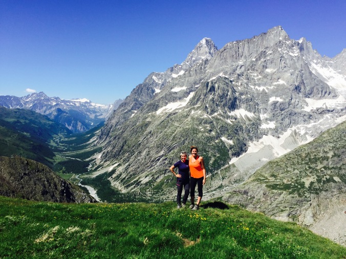
Turns out, we only spend one night in Italy. From Chalet Val Ferret, we took a switchbacking trail through a richly green meadow, just across the valley from a series of glowing glaciers from Mont Dolent. The trail moves steeply upwards until we reached Grand Col Ferret and took our first steps into Switzerland.
Our introduction to the Swiss Alps did not disappoint. A gentle, gradual trail took us through meadows and past glaciers to our lunchtime refreshment spot at Alpage de la Peule, a summer dairy farm. We continued on the TMB to La Fouly, where we planned to take a bus to our final destination for the evening. The stretch between La Fouly and Champex is similar to the morning stretch we skipped; unremarkable, flat, and easily skippable.
In La Fouly we discovered an ultra race for TMB runners was in full-swing. Racing contestants were coated in sweat and dirt, gaining high fives and cheers from their family members as they ran through town – and we learned that this was only their halfway point. The town was playing music at an open concert stage, and injured runners were limping in and out of the bus-stop-turned-infirmary. We watched the action from a rooftop bar and caught the bus at the opposite end of town.
Driving briefly through lakeside town of Champex, Kathleen and I decided if we’d done it all over again, we would have added an extra day here. A great example of classic Swiss culture in terms of food, drinks, and shops, Champex also boasts the best of lake life, with paddle boarders, canoes, and swimmers lapping through the water in the late afternoon. We learned there is a gondola that can take you above the lake for superb views and picnic spots, and promised we’ll be back in the future.
Day 5: Champex D’En Haut to Trient
Distance: 16km
Height gain: 742m
Height loss: 682m
Time: 5-5.5 hours
The auberge we stayed in, Champex D’En Haut, was a short bus ride or a 30 minute walk above the town of Champex. This meant we had a head start when we took off in the morning to begin our day. In terms of accommodation – this place was small, cozy, and a little crowded. Bags and shoes were left in a common room downstairs, and we squeezed six guys and girls into a tiny bunk bedded room. This was not the first time we were told that the auberge does not rent towels (see packing list below), and I distinctly remember sharing a single kitchen hand cloth between Kathleen and I to dry off after our showers. Also remembered: sneaking in Swiss beers and cheers-ing each other underneath the shower stalls.
To me, this day felt like the farthest we’d ventured from civilization. We were on our own and away from towns, power lines, and roads for nearly this entire day. It felt fun and familiar to hop over stream crossings and switchback up mountain passes. It was also going to be the shortest day we’d had so far since Day #1. By now our legs were strong and used to steep demands, so in a way, this day was truly a walk in the park.
We had lunch (read: pretzels and chocolate) at Alp Bovine, a wonderful little restaurant on top of a large pasture. I remember a few things in particular about this stop: (1), we met three sets of honeymooners completing this trek here and vowed we’d bring back our fiancés someday, and (2) we ordered lemonade and were served 7-Up.
From Alp Bovine, it wasn’t long to reach Col de la Forclaz, the most commercialized of all of the col crossings we’d done so far. A hotel, restaurant, souvenir shop, parking lot, and bus station sat on top of the pass. It was just a 30 minute descent into Trient, where we’d spend the night, so Kathleen and I felt no shame in indulging in another wine-fueled lunch and hopping on a bus to shortcut our day. It’d been a long week.

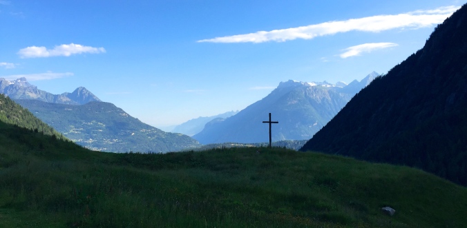
Trient is an adorable little settlement with dark wooded shuttered doors decorating every household, and brilliant red flowers popping out and adding color to the town. Our hostel was new and had a large backyard where kids could play and adults could enjoy the scenery (with a few adult beverages, of course). I remember that France was playing that night in the World Cup, and our hotel put up a projector outside to show the game on a big screen. The mountains loomed over the town’s lit-up chapel, providing another perfectly pleasant summer evening at high altitude.

Day 6: Trient to Tre Le Champ (Auberge le Boerne)
Distance: 18km
Height gain: 869m
Height loss: 978m
Time: 6 hours
We started early again, just as the sun was rising, and decided to take the longer and harder route since it was our second to last day. We followed along a mountainside in the shade for the better part of the morning until we came out into an exposed meadow where we could see our highpoint for the day.

As I’ve mentioned before, this was a heavy snow season, and many sections of the trail that should be been clear and dry by this time in the year were still covered in snow, which made navigating a little more difficult and a lot more fun. On this stretch of trail in particular, that meant shortcutting up and around a large snowfield that covered our path, which looked a little like crawling on hands and knees up an incredibly steep and slippery hillside.
Once on top, we felt like we could see across the entire world – when in reality we were mostly just looking at the Col de Balme before us, our final country crossing back into France. An old stone building sits on top of the col where we enjoyed coffee and hot chocolate on this chilly mid-morning, before setting out down the valley, where we could see Chamonix beyond.
On our way to Tre Le Champ we passed a couple who were hiking clockwise (opposite us), headed to Champex. When we told them we were staying in Auberge le Boerne, they warned us that the building was like the “old woman who lived in a shoe” nursery rhyme. Our expectations did not disappoint. Looking at the floor plan of the house, it seemed as though someone had quite literally tried to cram as many bunk beds on top of and next to each other as possible, layered like waffles. Picture winding stairs, and even a ladder, leading to crooks and nannies and attics filled with beds and people. Our poor friend was placed in the middle of three bunk beds with occupants on either side, which made a midnight bathroom run nearly impossible.

Day 7: Tre Le Champ to Chamonix
Distance: 25km
Height gain: 1540m
Height loss: 1800m
Time: 10-12 hours
Though these numbers measure the walking distance, height, and time, we were forced to take a few shortcuts on our final day. Our original itinerary was to stay in Lac Blanc overnight on this day, but by the time we were booking accommodations in January, the refuge here had already filled up (goes to show how popular of a trek this is, and how far ahead you should be prepared in advance). We also had a small window of clear weather in the morning before torrential rain would come in, so we moved fast.
Leaving Tre Le Champ, we followed a trail that zigzagged along the mountainside above the Chamonix valley, having the busy villages below in our sight almost all day long. After just a couple hours we emerged into a wide field for winter sports and followed ski lifts farther up the mountain. It had started to rain on us, so we donned our rain jackets, rain covers, and high-tailed it to the cable car at La Flegere.

We had almost zero visibility on this mountaintop as we sipped hot chocolate and coffee to warm us up before descending in a cozy, enclosed cable car and hopping on a bus to take us from Les Praz to Chamonix-Mont-Blanc city center.
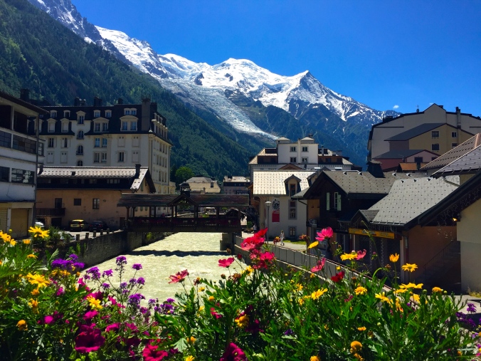
Chamonix is a world-class ski resort and adventure sports village for a reason. Every street corner sells a varied set of luxury fashion goods, ice climbing and snow gear, as well as top-notch Savoyarde restaurants featuring local French wines and cheese. Despite the rain, Kathleen and I made the most of our time in this town together and felt right at home amid the shopping and gastronomic adventures.
Our experience on the TMB was truly unforgettable. While I’m glad we got to complete this world-renowned hike as two young fit women, I can’t wait to return to this trail to run, cycle, or winter hike someday.
Overall, you should pack light for your TMB experience. As mentioned in the tips & tricks above, you’ll have constant access to food and water, and be able to buy toiletries along the way should you need. Think simple, think light, and don’t be afraid to rewear your sweaty clothes!
Packing List:
- Trekking poles (even if you’ve never used them before – trust us)
- Solid, comfortable hiking boots
- Crampons may be necessary in early season
- Nothing larger than a 40L backpack
- Always carry cash
- Hats (one with a brim for sun protection, one wool for evenings)
- Sunglasses
- Sunscreen – and use it! The sun shows no mercy at these altitudes
- Hand sanitizer
- Plenty of rain gear
- Towels, sleeping sheet or sleeping bag for auberges
- Very few personal toiletries


