With six weeks left until my upcoming North Cascades climbs, I need to intensify my endurance training. I’ll be doing two back-to-back climbs on mountains averaging around 10k ft. in altitude, and as I’ve learned from past experiences, the only way to prepare for that is to run, hike, and climb with as much elevation gain as possible on my weekend training days.
Muir Beach is one of the first trails I discovered when I moved to SF, and has stuck to be one of my favorites. I’ve brought my parents, out-of-town friends, and regular hiking buddies here. Its out-and-back style makes it an easy route to shorten or lengthen based on your mood. Here’s a distance breakdown of popular turn-around points:
- Muir Beach to Coastal Fire Road intersection: 2.2 miles
- Muir Beach to Tennessee Valley: 3.1 miles
- Muir Beach to Hill 88: 4.5 miles
- Total one-way from Muir Beach to Rodeo Beach: 5.9 miles

Quarter-mile into the hike, looking down at Muir Beach.
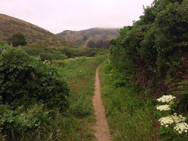
I chose the perfect day, with San Francisco’s famous fog hanging overhead for most of the morning. It was chilly, but easy to warm up with the waterfront hills.
The first half mile is steep. The entire trail follows the coastline and winds up and down its peaks, and in and out of its valleys. You’re essentially walking (or running) from a lower elevation to a higher elevation and back the entire time, which some may find completely exasperating, or to others, as a challenge.

Shoreline views from the Coastal Trail.
About halfway between Muir Beach and Tennessee Valley is a turnoff for Pirate’s Cove, a hidden little beach surrounded by tall, wind-swept and sea-swept rocks. At this intersection you’ll find one of two sets of rugged, wooden stairs on the trail that will slow down traffic a little. When trail running, this is one of the only spots that I’ll need to halt my speed to trudge up each step.
Just one more up-and-over and the trail widens as it merges with a fire road for the final stretch into Tennessee Valley.

Top of the fire road, looking down at Tennessee Valley – shoreline hidden by the hills.
When the fire road intersects with another wide trail, turn left for just 100 yards and you’ll see the continuation of the Coastal Trail on your right, with a mileage sign to Rodeo Beach. The walk from this intersection to the Tennessee Valley shoreline is 0.7 miles, which would’ve added 1.4 miles to my trip. I’ve done this option before and turned around at the beach, making the total hike around 7 miles.
Being in the valley means you’ve lost all of that legwork you did to get yourself up those hills, which also means you get to repeat that effort to get over to Rodeo Beach. To emphasize; it’s a lot of steep, steep hill climbing, and there’s not much benefit to the up-and-down nature of the path other than sheer enjoyment.
Leaving Tennessee Valley to go up, up, up and over to Rodeo Beach.
Here’s the most fun part of the trail. In the course of 1.15 miles, the Coastal Trail gains 800′ in elevation and peaks out at an exposed, windy plateau overlooking Tennessee Valley and even farther on. Continue up this hill to the tallest point of the day, and you’ll intersect a paved cycling road. Turning left here takes you a quarter mile to Hill 88. I’ve used this as a landmark too, returning to Muir Beach from Hill 88 makes a little more than a 9 mile track.
Turning right instead, the trail winds another mile and a half or so down to Rodeo Beach, which will probably be more crowded than Muir Beach. Make your way all the way down to the sand, and you get to look back and see all of the miles and elevation you get to do all over again on your return!

Overlooking Rodeo Beach, with views of the Golden Gate Bridge barely visible in the background.
QUICK STATS
- Length: 11.8 miles
- Elevation gain: 3.5k ft.
- Time: 3.25 hours

Looks like a very scenic training grounds. What climbs in North Cascades are you planning to do if you don’t mind me asking.
LikeLike
I’m going up Mt. Shuksan and Mt. Baker the week of June 22. I see you’ve been near that area, around the PNW at least!
LikeLiked by 1 person
Cool. I haven’t climbed Shuksan but I summited Baker before. It’s a really nice climb with amazing views from the top. Hope the weather is nice that week.
North Cascades are my favorite. I live in Seattle so I have a chance to visit often. 🙂
LikeLike
Pingback: Alamere Falls via the Coastal Trail | Rachy Davy